
The Milot Archaeological Project (2015-present) is a collaboration between the University of California, Santa Cruz, the Bureau National d’Ethnologie (BNE), the Musée du Panthéon National Haïtien (MUPANAH), and the Institut Sauvegarde du Patrimoine National (ISPAN). The MAP is researching the royal palace of Sans-Souci and neighboring sites in Milot, Haiti, to understand the materiality of sovereignty Kingdom of Hayti, a short-lived experiment in political order in the wake of the Haitian revolution.
The Palace of Sans-Souci
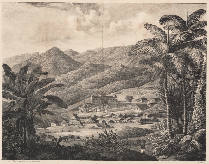
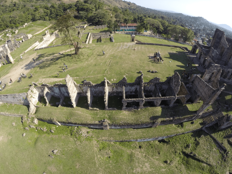
Situated at the base of the Bonnet à l’Eveque mountain, Sans-Souci represents the crowning achievement of Henry Christophe’s reign as King of the Kingdom of Hayti. Spanning 13 hectares, the expansive complex includes the royal residence, a queen’s residence, stables, barracks, gardens, prisons, an arsenal, several maintenance workshops, a hospital, and administrative buildings such as the mint, the Great State Council, the library, etc. The official entry consists of two porticoes formed by four monumental pillars, flanked to the east by the royal chapel, a circular building coiffed by a slate covered dome. The palace itself housed banquet and reception rooms, the monarch’s workroom, the private apartments of the king and queen and their daughters, and the quarters of the domestics and staff of the royal family. Sans-Souci was thus described as a veritable Versailles in the Caribbean because of its splendor. Oft-cited traditions claim the palace was built rapidly between 1811 and 1813, early in the reign of Christophe as King. However, historical sources indicate Christophe was building on the site as early as 1804, and Habitation Milot was a major sugar plantation in the 18th Century, suggesting a deeper construction and occupation history on the site.
In the early 1980s the ISPAN (l’Institut Sauvegarde du Patromoine National) and UNESCO conducted an exhaustive architectural survey at Sans-Souci in preparation for its inscription as a UNESCO World Heritage Site. Preliminary archaeological testing by ISPAN in the 1980s targeted the cour caimitier, a long platform that extends east-west across the palace landscape, the royal gardens, and the palais des ministers, a long multi-room structure aligned along the southern edge of the cour caimiter. This survey and excavation campaign revealed a number of walls projecting outwards from below the royal foundations as well, suggesting a significant level of construction took place prior to the royal era.
In 2015, the Milot Archaeological Project, renewed archaeological surveys and excavations at Sans-Souci. The project integrates digital methods, with traditional excavation techniques, to provide a comprehensive perspective on the architectural landscape of Sans-Souci. The goals of the project include documenting standing architecture for the purposes of site planning and management, providing and archaeological understanding of the construction history of the site, and documenting shifting life ways and material tastes from domestic contexts over time as a window onto the relationship between material culture and political sovereignty in post-independence Haiti.

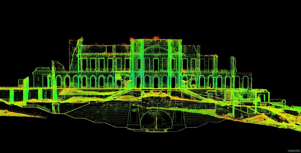
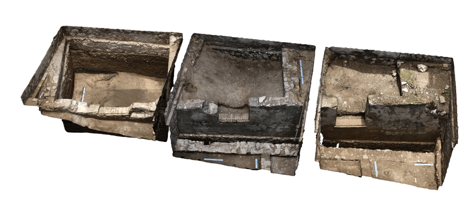
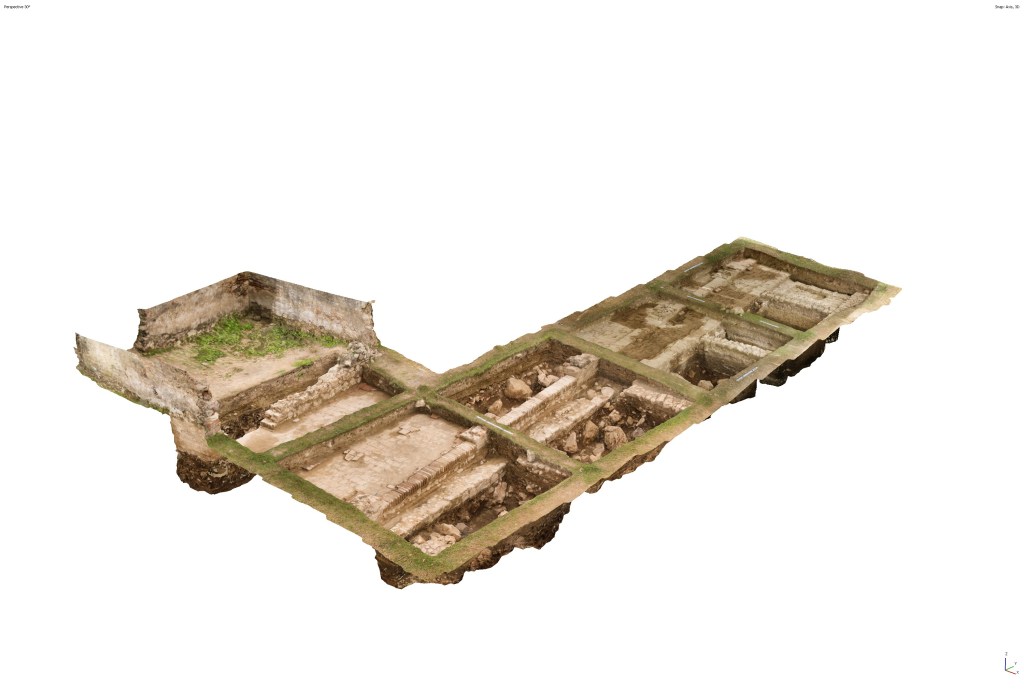
Our campaign included a comprehensive 3D scanning survey and targeted ground-penetrating radar (GPR) campaign. The scanning campaign has resulted in the creation of a new site plan, as well as a range of 3D visualizations.
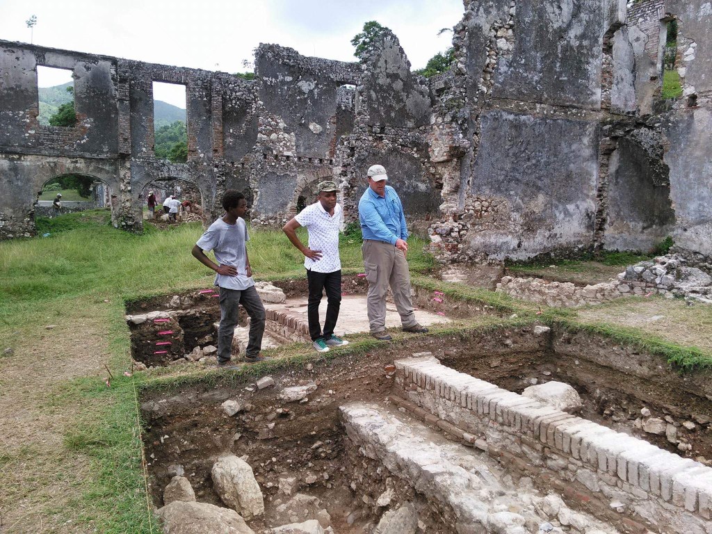
Our excavations targeted areas with the potential to provide a window onto the building chronology of the site, as well as a sample of domestic material culture from various contexts and phases. This research targeted two areas of the site; the Palais des Ministres (Area A) and the Palais de la Reine (Area B)
Area A (Palais des Ministres)
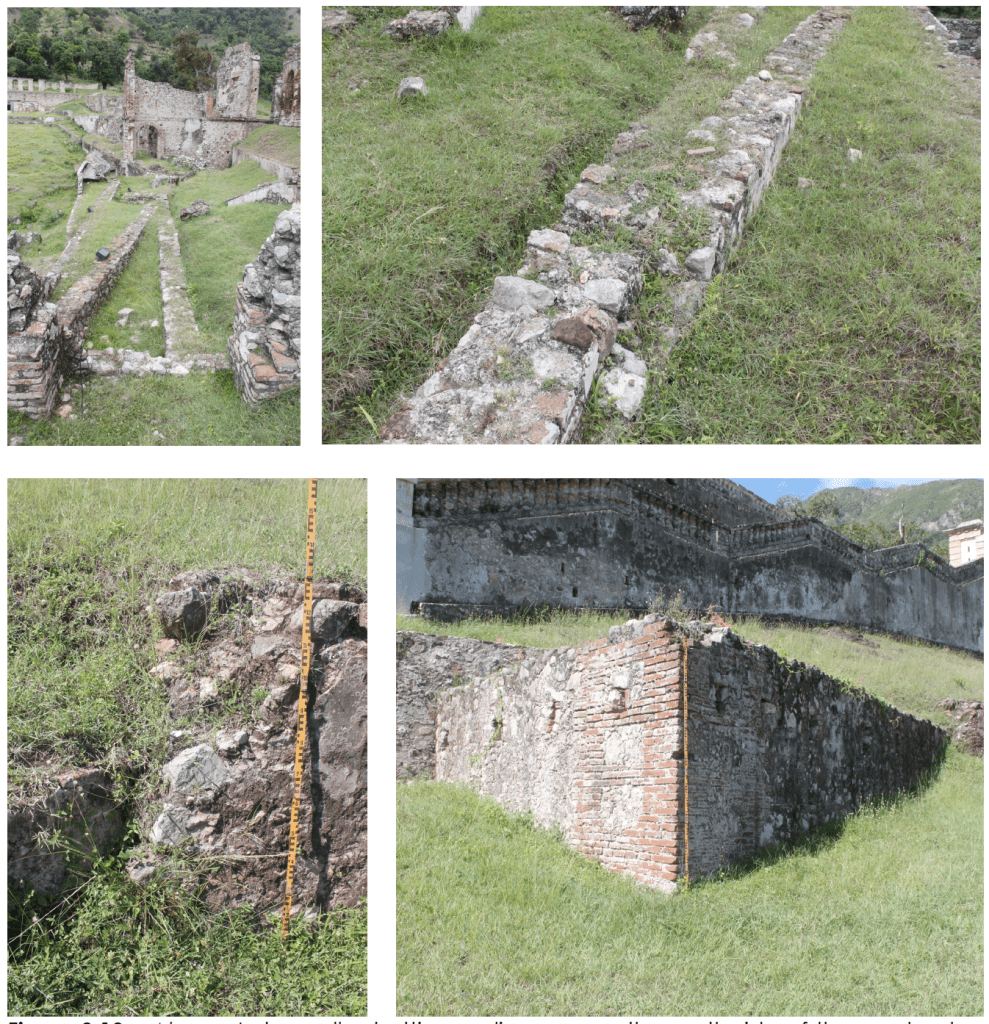
ISPAN’s excavations in the Palais des Ministres identified the walls of a second multi-roomed structure and associated staircase, constructed prior to the Royal Era of building activity at Sans-Souci. Between 2015 and 2019 the Milot Archaeological Project re-opened excavations in 3 rooms on on its far western end (Rooms 1-3) designated Area A1, and 2 rooms on its far eastern end (Rooms 10 and 11) designated Area A2, revealing a complex stratigraphic sequence including multiple phases of construction and occupation.
Excavations in Area A1 were initiated at the floor level of the Royal Era phase of construction. Just below the floor levels of all three rooms, the MAP identified layers of stone, brick, and mortar construction fill, used to prepare the area for the massive building effort above. This fill was deposited directly on top of the three rooms identified by ISPAN, as well as and an exterior walkway of the earlier building previously identified. This structure thus appears to have been built on an analogous plan to the later Palais des Ministres of the Royal Era complex.
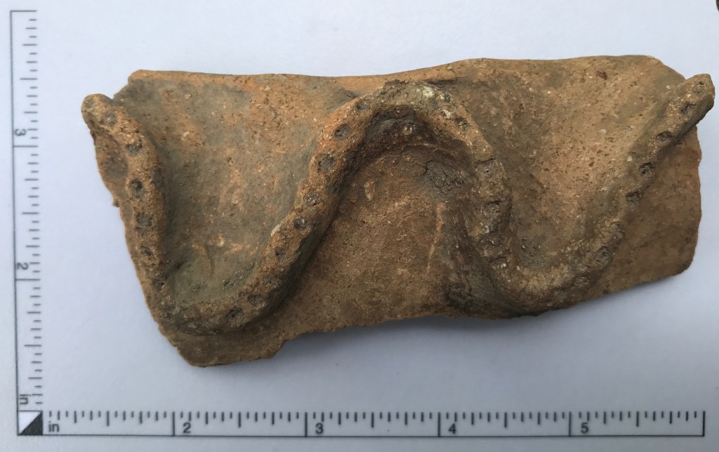
Below the floor of this earlier building, we identified stratified layers of an artifact-rich domestic trash deposit more than a meter thick. This material passed under the foundations of the earlier building and thus predated it. This midden was rich in imported and local material culture and fauna, and contained a few English potsherds sherds dating to the early 19th century. This midden thus post-dates the revolution, and corresponds to the years before large scale construction began at Sans-Souci.
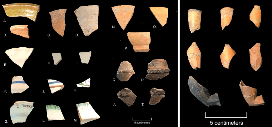
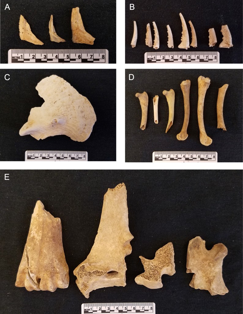
Below this domestic midden, we identified a layer of sterile sand, capping a second midden, containing iron fragments, cattle bones, and indigenous meillacoide pottery of the ninth to the sixteenth centuries. This denotes the presence an indigenous settlement with a terminal phase of occupation dating to the contact period. Thus, excavations in Area A2 revealed three phases of construction and occupation prior to the construction of the Royal Era complex during Christophe’s reign. Two of these post-dated the Revolution, and one dated to the period of fist contact with the Spanish.
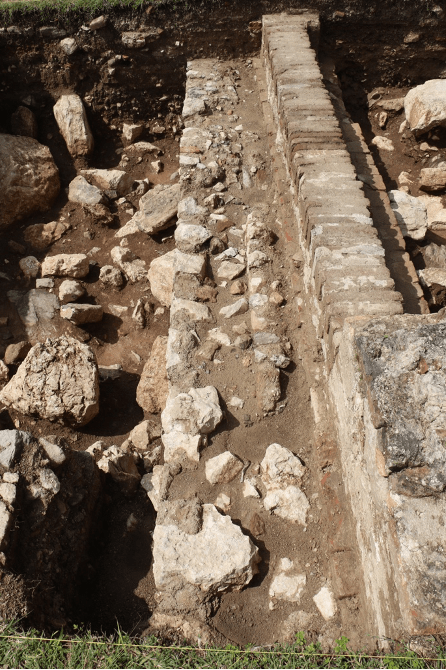
In 2018 the MAP reopened ISPAN’s excavations in rooms on the eastern extent of the Palais des Ministres, designated Area A2. ISPAN’s excavations identified a large staircase ascending to the west, and leading to a wall of unknown function. The MAP’s excavations in these rooms identified a mortar floor for the room associated with the final phase of construction in the Palais des Ministres. This floor sealed almost a meter of construction debris, which, in turn, capped the wall previously identified by ISPAN. This wall turned out be a retaining wall for a plaster-paved terrace extending to the northwest and under the Cour Caimitier. This terrace was reached by the stair case identified by ISPAN in the room to the east.

Excavating below the plaster-paved terrace, our excavations revealed a second structure on the same alignment. Thus, like Area A1 to the west, Area A2 revealed two phases of construction and occupation prior to the construction of the Royal Era complex during Christophe’s reign. This stairway leading to a plaster platform, also appears to represent a precursor to the monumental stairway constructed to the east during the Royal Era.

Area B (Palais de la Reine)
In 2017 the Milot Archaeological Project initiated excavations in the Palais de la Reine, designated Area B. Excavations on the east side of the structure identified a small section of the Royal Era building’s interior, the piers of an exterior arcade, an exterior brick threshold, and carriage tracks extending outwards in the courtyard facing the structure. Additionally, these excavations revealed the remains of a clay tile and mortar floor that extended across both the arcade and the building’s interior, as well as out onto a patio to the east.

Excavations below the Royal Era floor material of the arcade and exterior patio, however, revealed a second wall foundation. This foundation rests just to the east of the brick arcade threshold and associated piers, and the two features diverge by 1.5 degrees. This foundation thus represents an earlier structure, one possibly torn down during the construction of the Palais de la Reine.
This earlier structure was dug into a layer of construction fill composed of a mix of soil, stone, broken brick, fragmented roof tiles, both clay and white marble tiles, and range of artifact types that extended across all units. The assemblage of artifacts recovered in this layer was essentially identical to that collected in an early 19th-Century trash deposit in Area A, yet the high frequency of fragmentary structural debris suggests an existing building was torn down nearby in the process of leveling the area. Collectively this archaeological evidence confirms the presence of 1, and possibly 2 earlier phases of construction on the site of the Palais de la Reine, both dating the period after the end of the Revolution.
Collectively, this research has clarified at least 3 phases of construction activity at the site, identified domestic material culture associated with 2 of those phases, an documented an indigenous presence at Sans-Souci as late as the 16th century. Future research will continue to explore the cultural history of the site, as well as related domestic contexts in Milot.
